Tour de France Climbs
Col du Galibier from Saint Michel de Maurienne
| Lenght | Elevation | Average Gradient % | Done |
| 34.9 | 1924 | 5.5 |
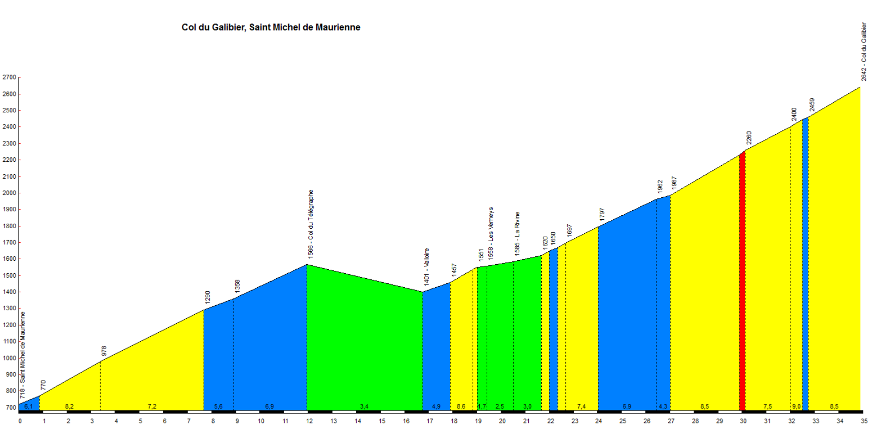
The Col du Galibier combines extreme high altitude (2,642 meters above sea level), a uniquely harsh environment, and over a century of epic feats in the Tour de France.
First included in the race in 1911, it has become a symbol of the Tour. Cycling legends such as Gino Bartali (1937), Fausto Coppi (1952), Eddy Merckx (1969), and Marco Pantani (1998) have all crossed it—either as stage winners or as key protagonists.
At the summit stands the *Souvenir Henri Desgrange*, a monument dedicated to the founder of the Tour. It is not merely an isolated climb; it often serves as the climax to grueling stages. Approaching from the north requires a two-part ascent (frequently combined with the Col du Télégraphe), while the final kilometers—above 2,000 meters—feature sustained, demanding gradients that reach peaks of over 10–12%.
The road winds through a rugged, wild high-mountain landscape, where the weather can shift abruptly, bringing wind, cold, and even snow—even in the middle of summer.
For more information, visit this page.
Mont Ventoux from Bedoin
| Lenght | Elevation | Average Gradient % | Done |
| 22.7 | 1622 | 7.1 |

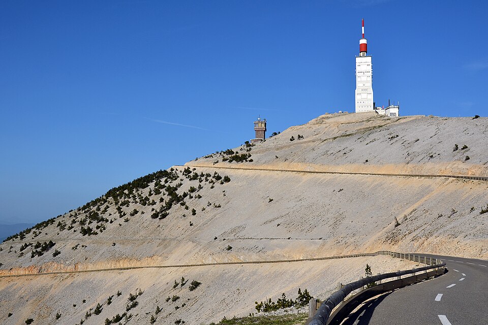
Mont Ventoux (known as the “Giant of Provence” or the “Bald Mountain”) is one of the most anticipated and feared climbs in the Tour de France.
The classic ascent from Bédoin spans 20.8 km, with an elevation gain of approximately 1,594 meters and an average gradient of 7.7% (with sections exceeding 10–11%).
After the relatively easy opening kilometers leading to Saint-Estève, the road enters a dense forest, where the gradient remains consistently between 9% and 10% for about 10 kilometers.
Upon emerging from the forest near Chalet Reynard, all vegetation disappears. The summit area is covered in white scree—resembling snow or a lunar landscape—which makes the mountain recognizable from dozens of kilometers away.
The name itself (“Ventoux,” similar to the French word venteux, meaning “windy”) describes one of its defining features. At the summit, the Mistral wind can blow in extremely violent gusts—sometimes exceeding 300 km/h—turning the act of balancing on a bicycle and moving forward into a genuine battle against the elements.
In reality, the name likely derives from the pre-Gallic term ventur—which later passed into the Occitan language—meaning “that which can be seen from afar.”
In 1967, British cyclist Tom Simpson died on its slopes due to exhaustion and extreme heat—a tragic event that transformed the mountain into a place both mythical and unforgiving. It has been the stage for legendary duels (such as the one between Marco Pantani and Lance Armstrong in 2000) and remarkable athletic feats.
Tom Simpson’s death on Mont Ventoux served as a historic turning point in the global fight against doping in sports. At the exact spot where he died, there now stands a memorial dedicated to him, bearing the inscription: “There is no mountain too high”.
Mont Ventoux was first included in the Tour de France in 1951, during a stage that started in Montpellier and finished in Avignon. A true summit finish on Mont Ventoux was introduced later, in 1958 (stage 18, won by Charly Gaul).
It is not merely a sporting icon; On April 26, 1336, the humanist poet Francesco Petrarca (Petrarch) completed the first documented ascent in modern history, recounting it in his famous “Letter from Mount Ventoux” as a symbol of spiritual elevation and introspection
More information here:
- https://it.wikipedia.org/wiki/Mont_Ventoux
- Cassani post on Mont Ventoux
- The tragedy of Tom Simpson on Mont Ventoux
Col du Grand Saint Bernard from Orsieres
| Lenght | Elevation | Average Gradient % | Done |
| 30.6 | 1752 | 5.7 |
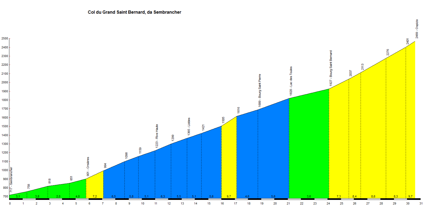
The ascent to the Great St. Bernard Pass, on the border between Italy and Switzerland, boasts a history spanning millennia. While it has served as the setting for extreme physical challenges, it is also a place of spirituality and beauty, defined by extraordinary high-altitude landscapes.
The pass has been frequented since the Bronze Age and the time of the Celts; during the Roman era, it was home to a temple dedicated to Jupiter Poeninus. In May 1800, Napoleon Bonaparte crossed the pass with an army of approximately 40,000 men during his second Italian campaign—a feat immortalized in the famous equestrian portrait by Jacques-Louis David.
For centuries, it was one of the most significant and perilous stages for pilgrims traveling to Rome, a route documented as early as the 10th century by Archbishop Sigeric. Around 1035–1045, Saint Bernard of Menthon founded the renowned Hospice at the highest point of the pass to provide shelter and care to travelers caught in the cold or threatened by bandits. It was at this hospice that the famous St. Bernard dogs were developed; trained by the canons, they were used to search for and rescue people lost in the snow—an image now inextricably linked in the popular imagination to the iconic, albeit legendary, small barrel of liqueur.
For cyclists, the ascent is a true “monument.” The Italian side, beginning in Aosta, stretches for over 34 kilometers with an elevation gain of nearly 1,900 meters and demanding gradients; it has been featured multiple times in both the Giro d’Italia and the Tour de France.
Between 1920 and 1957—and later revived—the route also hosted the celebrated Aosta–Great St. Bernard hill-climb motor race. The ascent to the Col du Grand-Saint-Bernard was included in the Tour de France for the first time in 1949 (during the 18th stage from Aosta to Lausanne), with the Italian Gino Bartali being the first to reach the summit.
More info here:
- https://it.wikipedia.org/wiki/Colle_del_Gran_San_Bernardo
- https://it.wikipedia.org/wiki/Bonaparte_valica_il_Gran_San_Bernardo
- https://www.giroditalia.it/colle-del-gran-san-bernardo/
Col de la Croix de Fer from Saint Jean de Maurienne
| Lenght | Elevation | Average Gradient % | Done |
| 30 | 1522 | 5.1 |
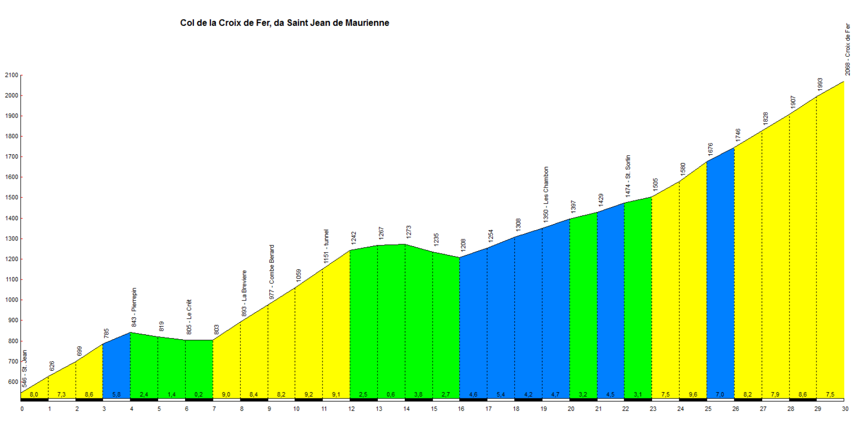
The Col de la Croix de Fer is a true classic, regularly featured in the Tour de France as an Hors Catégorie (beyond category) climb. It has served as the stage for epic battles between some of the greatest champions in the history of cycling—from Gino Bartali and Fausto Coppi to Bernard Hinault and Richard Virenque.
First included in the Tour in 1947, it has been tackled 21 times between 1947 and 2022.
The ascent spans approximately 28–29 kilometers, with an elevation gain exceeding 1,500 meters (from either of its two main approaches: Saint-Jean-de-Maurienne or Allemond).
Unlike more consistent climbs, its profile is irregular, featuring false flats, short descents, and demanding ramps with gradients reaching or exceeding 10–11%—gradually wearing down the cyclists’ legs, meter by meter.
Located just a few kilometers from the legendary Col du Glandon, it often facilitates the creation of grueling Alpine stages. It takes its name from an old wrought-iron cross situated near the summit, set within a rugged Alpine landscape dominated by the peaks of the Aiguilles d’Arves and vast artificial reservoirs, such as the Grand’Maison dam.
More info here:
- https://www.gazzetta.it/bici/turismo/30-08-2021/col-de-croix-de-fer-bici-scalata-valle-dell-arvan-420743343440.shtml
- https://www.bikeitalia.it/2025/10/30/scalata-a-croix-de-fer-e-mollard-due-salite-iconiche-del-tour-de-france/
- https://it.routedesgrandesalpes.com/grands-cols/croix-de-fer
Col du Grand Colombier from Culoz
| Lenght | Elevation | Average Gradient % | Done |
| 18.3 | 1255 | 6.9 |

The Col du Grand Colombier (located at 1,498 m above sea level in the Jura Mountains, France) is one of the toughest climbs in Europe—often classified as Hors Catégorie (HC). It features brutal gradients that, in some sections, exceed 12–14%, with extreme peaks reaching as high as 22% on the western approach from Artemare.
The pass can be ascended from four different directions (Culoz, Anglefort, Artemare, and Virieu-le-Petit), each with its own unique characteristics; all routes span over 15–17 km and maintain demanding average gradients of around 7–8%.
The ascent from Culoz is particularly famous for its spectacular, tight, and steep hairpin bends—known as “les lacets du Grand Colombier”—which wind their way up the rocky mountainside.
Since 2012, the climb has frequently featured in the Tour de France (la Grande Boucle)—hosting memorable stage finishes—and has earned a reputation as a decisive, selective challenge capable of separating the world’s best climbers.
Compared to other, more renowned Alpine passes, it offers a wilder, less crowded environment, along with extraordinary 360-degree views that stretch from Lac du Bourget and the Rhône Valley all the way to Mont Blanc
More information here:
- https://it.routedesgrandesalpes.com/grands-cols/col-du-grand-colombier
- https://www.youtube.com/watch?v=oK78qPb3-uQ
- https://it.wikipedia.org/wiki/Col_du_Grand_Colombier
Col du Tourmalet from Saint Marie de Campan
| Lenght | Elevation | Average Gradient % | Done |
| 17.2 | 1268 | 7.4 |
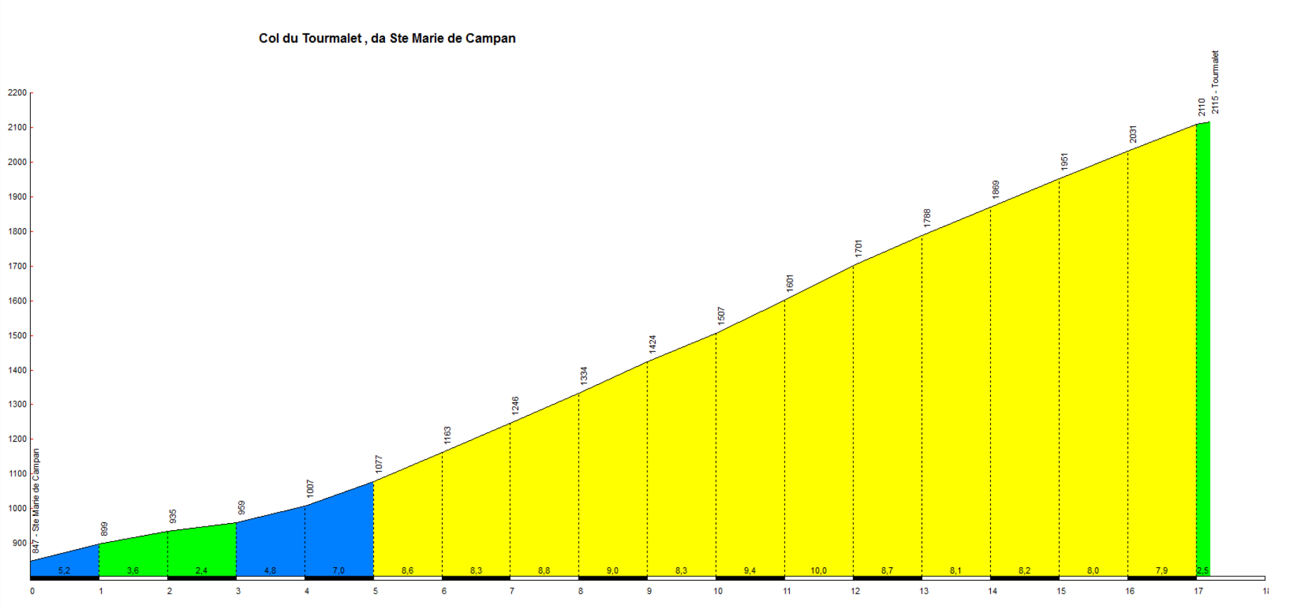
The Col du Tourmalet is the mountain pass most frequently featured in the history of the Tour de France; it was first traversed on July 21, 1910, with Octave Lapize being the first to cross it. Its name literally means “bad road” in the Gascon language.
Its slopes have hosted epic duels between cycling legends from every era, including Fausto Coppi, Miguel Indurain, Thibaut Pinot, and Tadej Pogačar (who holds the recent climbing records).
Unlike other modern ascents created solely for sporting purposes, the Tourmalet is a genuine high-mountain pass, set within a wild, pastoral landscape. At the summit stands the famous statue of Le Géant du Tourmalet (“The Giant of the Tourmalet”), which depicts a cyclist pedaling.
More information here:
- https://www.gazzetta.it/Ciclismo/tour-de-france/08-07-2026/ciclismo-tour-la-leggenda-del-tourmalet-da-coppi-a-merckx.shtml
- https://www.repubblica.it/sport/ciclismo/2021/07/15/news/storia_e_leggenda_del_tourmalet_la_montagna_piu_amata-310387632/
- https://cyclinside.it/pogacar-sul-tourmalet-ecco-quanti-watt-servono-per-fare-la-storia/
Col d’Iseran from Bonnevalle sur Arc
| Lenght | Elevation | Average Gradient % | Done |
| 13.43 | 977 | 7.3 |
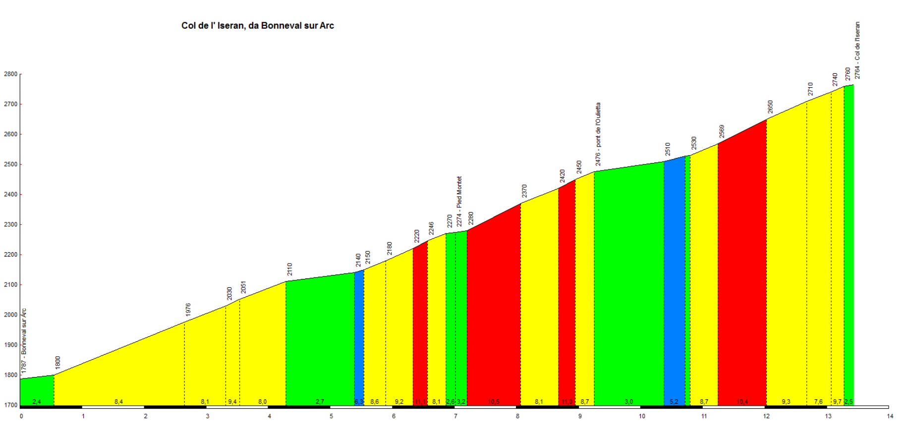
The Col d’Iseran is located within the Vanoise National Park, connecting the Maurienne Valley (starting from the village of Bonneval-sur-Arc) to the Tarentaise Valley (Val-d’Isère). It offers a landscape defined by glaciers, hairpin bends, and high-altitude stone walls.
At 2,770 meters (or 2,764 meters, depending on the measurement), it is the highest paved mountain pass in the Alps—and in all of Europe. It was included in the Tour de France for the first time in 1938, just one year after the official opening of the road (which took place on July 10, 1937).
Since then, despite its renown, the Grande Boucle has featured it on the route relatively few times, due to its extreme altitude and frequent bouts of bad weather during the summer.
The 2019 edition was particularly memorable: Egan Bernal reached the summit first, but the stage was subsequently halted due to a violent hailstorm and a landslide on the opposite side of the pass, forcing organizers to neutralize the race and freeze the standings at the very top of the climb.
In 1939, the pass hosted the first mountain time trial in the history of the Tour (running from Bonneval-sur-Arc to Bourg-Saint-Maurice), which was won by Sylvère Maes.
For cyclists, the southern approach—starting from Bonneval-sur-Arc—is the most compelling; it offers a wilder, steeper, and more spectacular experience, far removed from the ski lifts and tunnels that characterize the opposite side.
More information here:
Lac d’Aumar from Saint-Lary-Soulan
| Lenght | Elevation | Average Gradient % | Done |
| 24 | 1403 | 5.8 |
Col d’Aubisque from Laruns
| Lenght | Elevation | Average Gradient % | Done |
| 16.6 | 1190 | 7.2 |
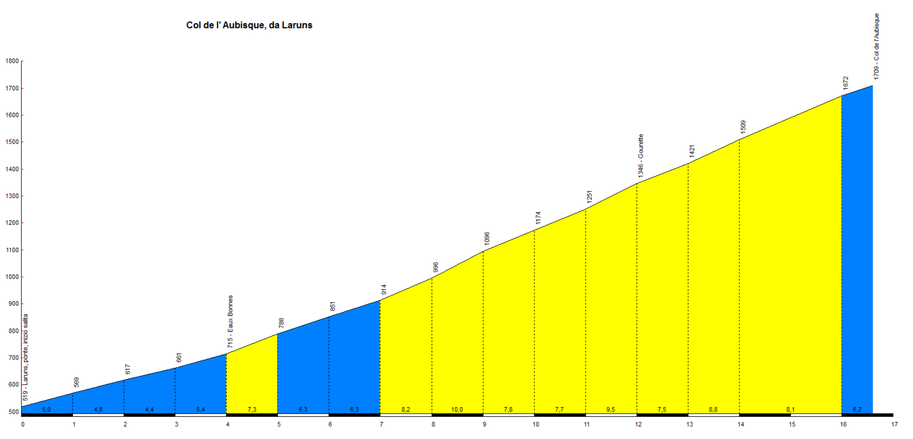
The Col d’Aubisque (1,709 m) is an absolute monument of world cycling. While neither the highest nor the steepest pass in the Pyrenees, it owes its legendary status to its long-standing history in the Tour de France, a unique stretch of road carved directly into the rock face—the only one of its kind in Europe—and the epic events that have unfolded there.
In 1910, it was included in the very first, daunting high-mountain stage in the Pyrenees: the 326-kilometer Luchon-Bayonne route, contested on unpaved roads. On that occasion, Octave Lapize reached the summit on foot, pushing his bike and shouting “Murderers!” at the organizers.
The climb has been featured in the Tour de France more than 70 times—a figure that makes it (tied with the Col d’Aspin) the second most-visited mountain in the race’s history, surpassed only by the Col du Tourmalet.
The eastern slope, which connects the Aubisque to the nearby Col du Soulor, passes through the Cirque du Litor—one of the most spectacular settings in the Pyrenees. This famous route en corniche (a cliffside road) is hewn directly into the living rock, featuring narrow tunnels and a sheer vertical drop overlooking the valley below; it remains one of the most iconic and frequently photographed spots in all of road cycling.
On July 17, 1951, while descending the eastern side of the Col d’Aubisque—along that very same cliffside road through the Cirque du Litor—Wim van Est, then wearing the yellow jersey, lost control and plunged more than 20 meters into a ravine. He survived, miraculously, and was hauled back up using a makeshift chain fashioned by knotting together dozens of bicycle inner tubes. In 2001, to mark the 50th anniversary of the accident, the organizers of the Tour de France—joined by Wim van Est himself—unveiled a commemorative plaque set into the roadside rock face at the exact spot where he had veered off the road.
As a testament to the enduring bond with the Grande Boucle, three massive bicycle-shaped sculptures stand at the summit, painted in the colors of the Tour’s iconic jerseys (yellow, polka-dot, and green).
Although the figures might seem more “manageable” than those of the Col de Portet, the ascent from Laruns harbors genuine challenges. It spans 16.6 km with an elevation gain of 1,190 meters and an average gradient of 7.2%; after a steady start leading up to the spa town of Eaux-Bonnes, the road climbs consistently at between 8% and 10% for the final 8 kilometers, with a maximum gradient reaching 13%.
More information here:
- https://www.gourette.com/it/itinerari/il-giro-del-col-daubisque-col-du-soulor-in-bicicletta/
- https://fr.wikipedia.org/wiki/Cirque_du_Litor
- https://en.wikipedia.org/wiki/Col_d%27Aubisque
Col de Joux Plane from Samoens
| Lenght | Elevation | Average Gradient % | Done |
| 11.1 | 989 | 8.9 |
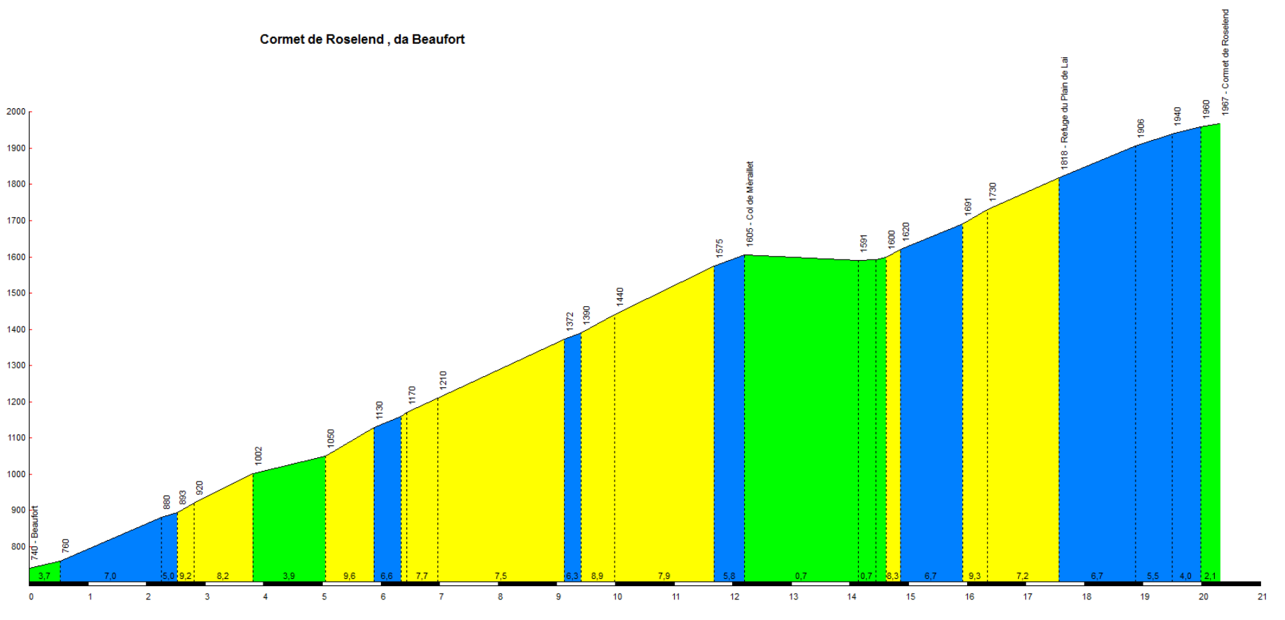
Cormet de Roselend from Beaufort
| Lenght | Elevation | Average Gradient % | Done |
| 20.32 | 1227 | 6 |
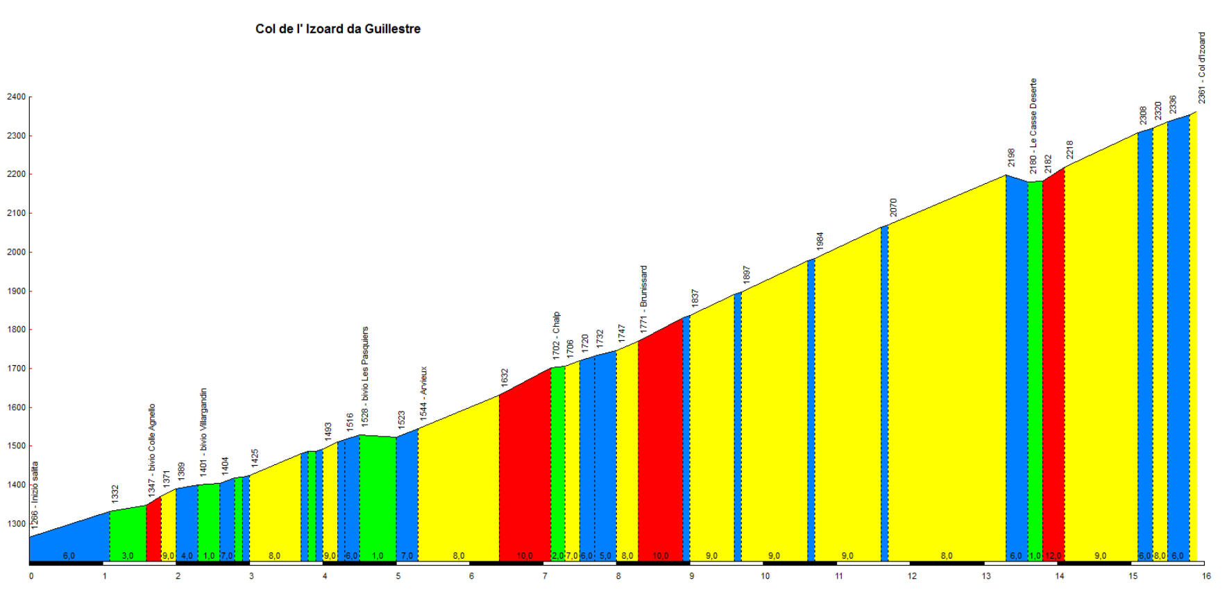
Col d’Izoard from Guillestre
| Lenght | Elevation | Average Gradient % | Done |
| 15.9 | 1095 | 6.9 |
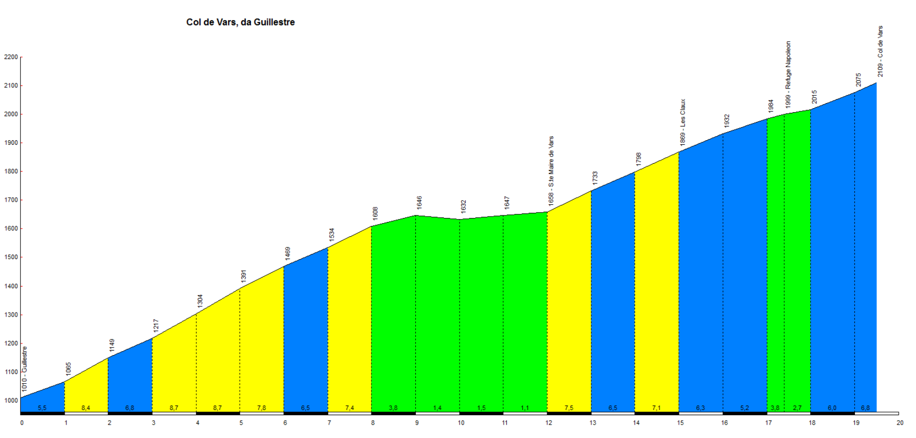
Col de Vars from Guillestre
| Lenght | Elevation | Average Gradient % | Done |
| 19.4 | 1111 | 5,7 |
Col du Chaussy from Pontamafrey
| Lenght | Elevation | Average Gradient % | Done |
| 14 | 1031 | 7.4 |

The Col du Chaussy (1,533 m above sea level, located in Savoy in the Maurienne valley) owes its fame to a unique mix of road engineering, breathtaking views and epic cycling.
The ascent almost always starts by tackling the famous 18 close hairpin bends of Montvernier (Les Lacets), built in 1934. Seen from above they look like a ribbon or a model car track (in French lacets means shoelaces).
After the hairpin bends, the road continues carved directly into the rock overlooking the valley, offering a dizzying and spectacular view of the surrounding peaks and the Aiguilles d’Arves.
It officially entered the history of the Tour de France in 2015 (during a very tough Alpine stage won by Vincenzo Nibali at the Croix de Fer finish line), instantly becoming one of the favorite passes of cycling enthusiasts.
With its approximately 13-14 km of ascent with average gradients of around 7.5% and peaks in double figures, it offers almost no respite and requires trained legs, while remaining less busy and wilder than the large nearby giants such as the Galibier or the Madeleine.
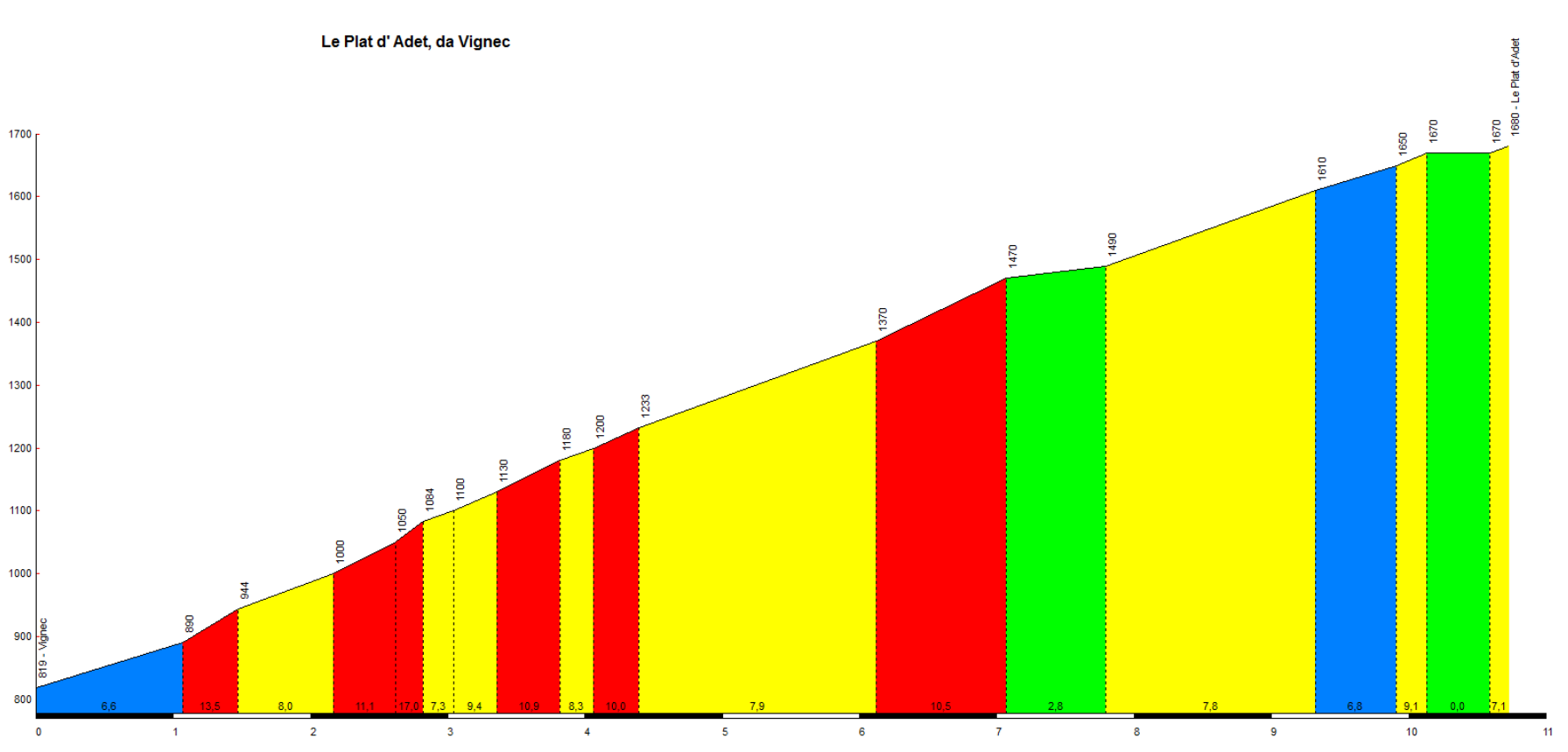
Pla d’Adet from Vignec
| Lenght | Elevation | Average Gradient % | Done |
| 10.73 | 861 | 8 |
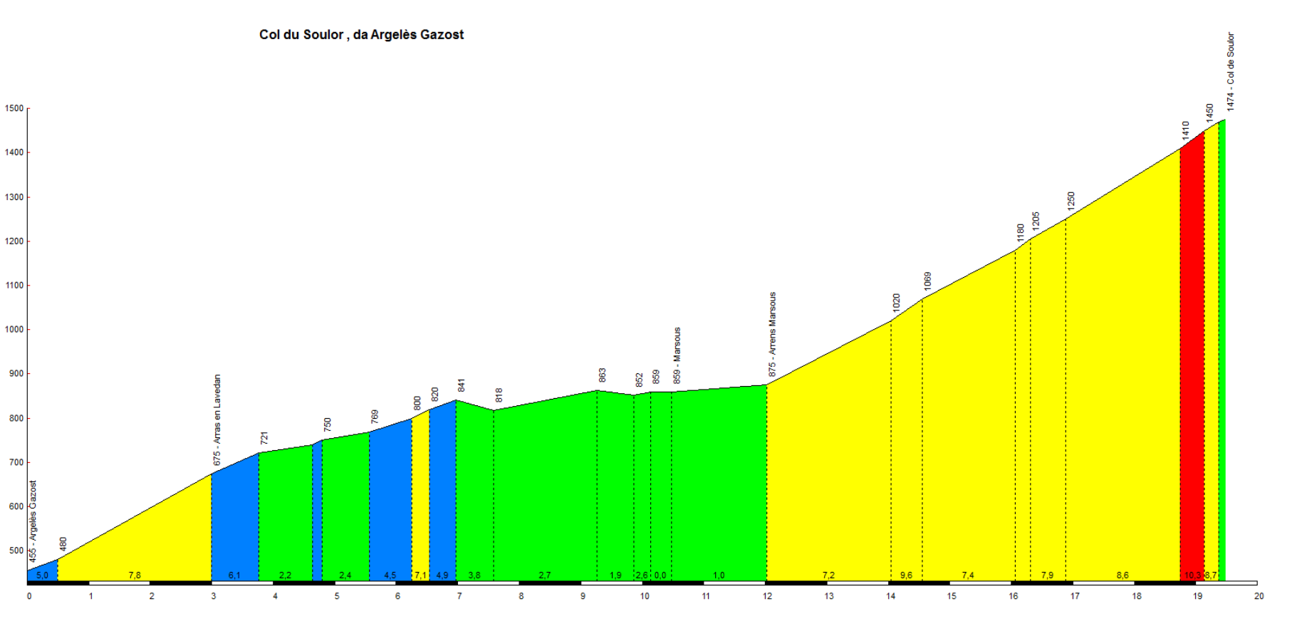
Col du Soulor from Arrens-Marsous
| Lenght | Elevation | Average Gradient % | Done |
| 19.48 | 10.19 | 5.2 |
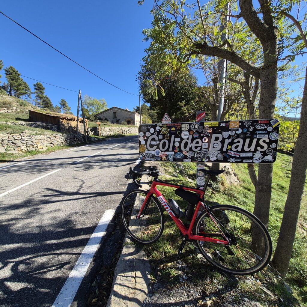
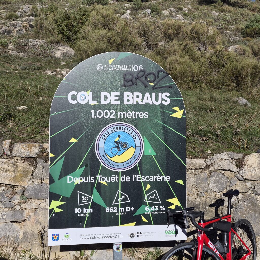
Col de Braus from L’Escarene
| Lenght | Elevation | Average Gradient % | Done |
| 10.3 | 662 | 6.4 | 27 Oct 2026 |

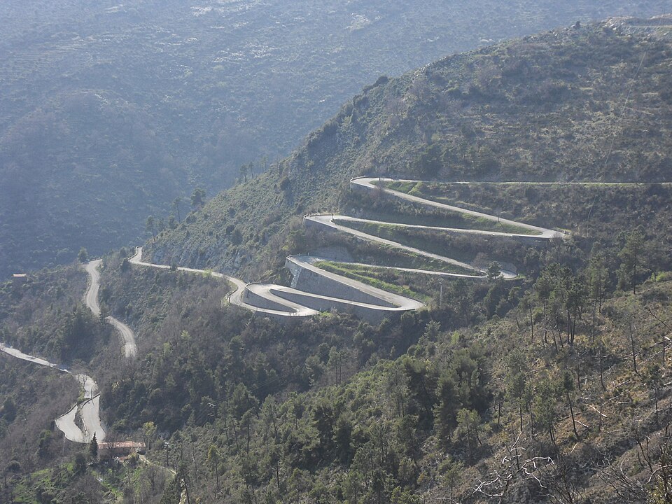
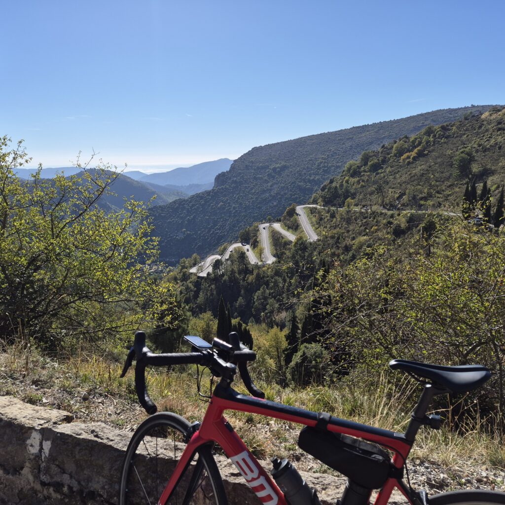
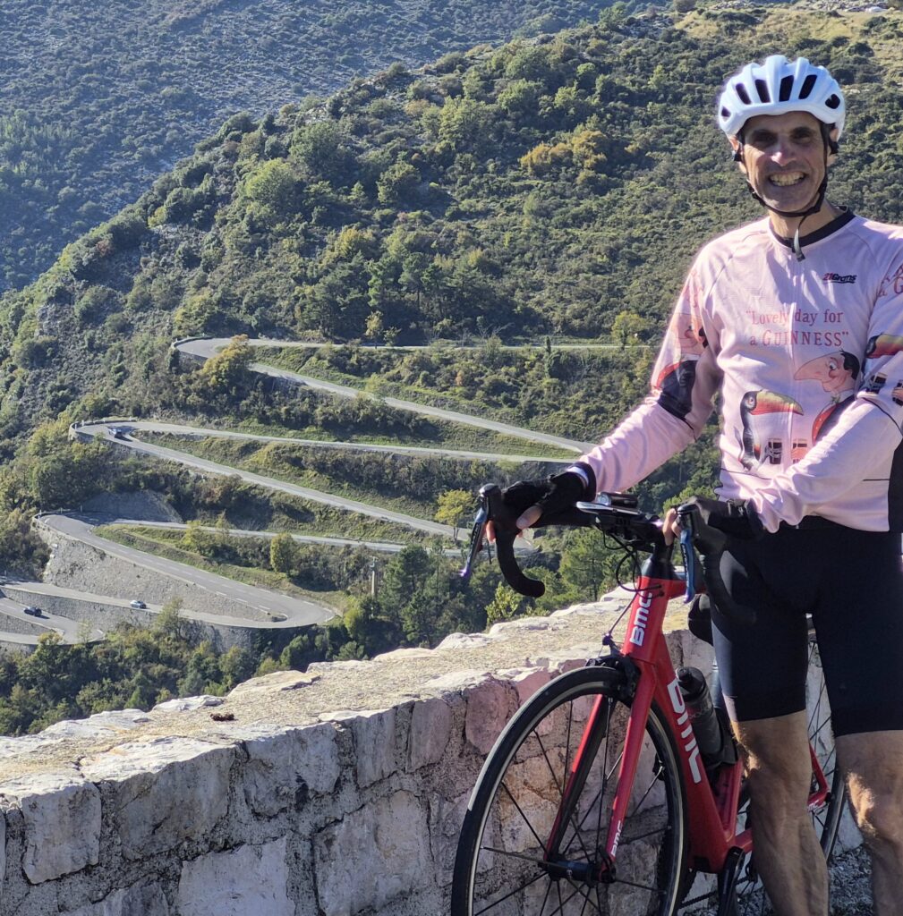
The Col de Braus, situated at an altitude of 1,002 meters in the French Maritime Alps, boasts an extraordinary sporting history and a truly distinctive layout (the famous “lacets”).
The road (D2204) is renowned for a dense series of stacked switchbacks and hairpin bends carved into the mountainside, offering spectacular valley views and a unique geometric design.
First included in the Tour de France in 1911, the pass has been tackled dozens of times in that famous stage race and frequently features in other major events, such as Paris-Nice.
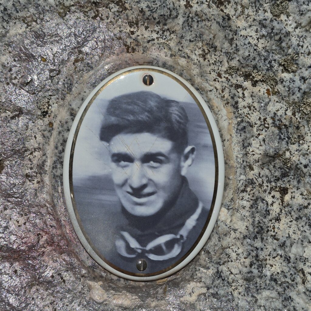
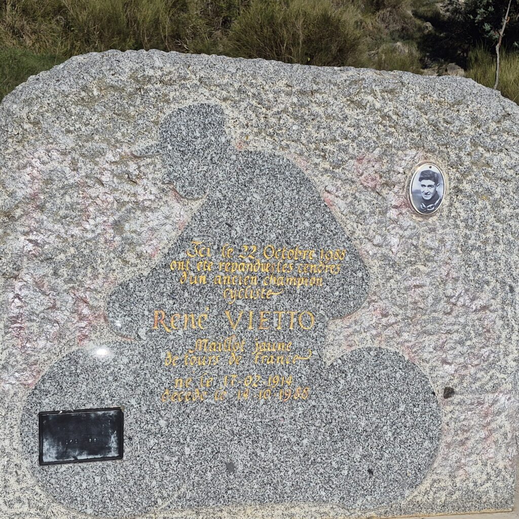
At the summit stands a monument to René Vietto—a legendary climber and icon of 1930s French cycling—who hailed from this region.
Beyond cycling, the pass is famous for having historically hosted special stages of the legendary Monte Carlo Rally, thanks to the challenging and technical nature of the route.